

Author: – Swara Bendre | Krvia – Post Graduate Program | 2020
“Disasters must be considered as an opportunity because of the high attention and goodwill they generate, and taking advantage of the situation to plan and design better infrastructure and mobilizing resources can result in resilient infrastructures, better local economies and livelihood.”
Gilbert Chilinde.
Urban Disasters impact the social, technical and economic systems of an area. The narrative of Resilience is being considered as a viable option to tackle urban disasters.
This could be applied for the issue of urban flooding in Mumbai as well. The reasons why Mumbai floods every single year in monsoon are intertwined. The heavy urbanization in the city attracts storm surges making the precipitation erratic and unpredictable. More it rains it becomes more difficult for the already inadequate drainage system within the city. Even the natural drainage system of mangroves and mudflats is compromised as it has been built on and hence depleting. Every year there are at least one or two days which experience rainfall more than 100mm/hr and high tide higher than 4.5 mts.

These issues when combined with the previous records of chronic flooding show us that there are 5 areas within Mumbai which are most vulnerable – Mahalkshmi, Kurla, Oshiwara, Poisar and Bhandup. All of them face coastal, riparian and spot flooding along with the rising threat of sea level rise. Oshiwara stands out when compared against other sites for other environmental, physical and social vulnerabilities.
Oshiwara faces waterlogging annually and riparian flooding in extreme rainfall situations. Along with this it has issues like ecological degradation, loss of biodiversity, dissociation of community with the waterbody and drop in desire to live in this area. Moreover, there is a lot of encroachment both along the river and on the vacant plots in between the formally built pockets.
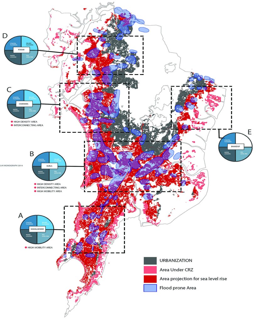
The way to tackle the issue of flooding in this area is to understand the strengths and opportunities that are presented in the form of open spaces. The idea is to increase more and more amount of pervious surfaces, for this various design, policy, collaborative and participatory strategies like buffer zones along the river to include more blue-green infrastructure, rain water co management in the built areas around and converting regular open spaces to mitigation greens can reduce the load of storm water management on the main grid. Community aid to improve and maintain the locality can be introduced in this area to achieve social, economic and most importantly flooding resilience.
Text & Images Credit: Swara Bendre | Krvia Post Graduate Department | Urban Design | 2020
Click line below to view panels as guest https://app.conceptboard.com/board/ikka-s9pu-hds0-1c6d-2nff#

Leave a comment